Hofstetten, Baden-Württemberg References Navigation menuViewDeeplGoogle Translate48°15′29″N...
AchernAppenweierBad Peterstal-GriesbachBerghauptenBiberachDurbachEttenheimFischerbachFriesenheimGengenbachGutachHaslachHausachHofstettenHohbergHornbergKappel-GrafenhausenKappelrodeckKehlKippenheimLahrLaufLautenbachMahlbergMeißenheimMühlenbachNeuriedNordrachOberharmersbachOberkirchOberwolfachOffenburgOhlsbachOppenauOrtenbergOttenhöfen im SchwarzwaldRenchenRheinauRingsheimRustSasbachSasbachwaldenSchuttertalSchutterwaldSchwanauSeebachSeelbachSteinachWillstättWolfachZell am Harmersbach
Municipalities in Baden-WürttembergOrtenaukreisFreiburg region geography stubs
OrtenauBaden-WürttembergGermany
This article may be expanded with text translated from the corresponding article in German. (February 2009) Click [show] for important translation instructions.
|
Hofstetten | ||
|---|---|---|
| ||
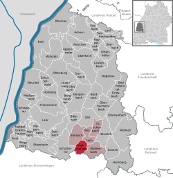
Location of Hofstetten within Ortenaukreis district  | ||
 Hofstetten Show map of Germany  Hofstetten Show map of Baden-Württemberg | ||
| Coordinates: 48°15′29″N 08°03′57″E / 48.25806°N 8.06583°E / 48.25806; 8.06583Coordinates: 48°15′29″N 08°03′57″E / 48.25806°N 8.06583°E / 48.25806; 8.06583 | ||
| Country | Germany | |
| State | Baden-Württemberg | |
| Admin. region | Freiburg | |
| District | Ortenaukreis | |
| Government | ||
| • Mayor | Henry Heller | |
| Area | ||
| • Total | 18.15 km2 (7.01 sq mi) | |
| Elevation | 259 m (850 ft) | |
| Population (2017-12-31)[1] | ||
| • Total | 1,766 | |
| • Density | 97/km2 (250/sq mi) | |
| Time zone | CET/CEST (UTC+1/+2) | |
| Postal codes | 77716 | |
| Dialling codes | 07832 | |
| Vehicle registration | OG | |
| Website | www.hofstetten-schwarzwald.de | |
Hofstetten is a town in the district of Ortenau in Baden-Württemberg in Germany.
References
^ "Bevölkerung nach Nationalität und Geschlecht am 31. Dezember 2017". Statistisches Landesamt Baden-Württemberg (in German). 2018..mw-parser-output cite.citation{font-style:inherit}.mw-parser-output .citation q{quotes:"""""""'""'"}.mw-parser-output .citation .cs1-lock-free a{background:url("//upload.wikimedia.org/wikipedia/commons/thumb/6/65/Lock-green.svg/9px-Lock-green.svg.png")no-repeat;background-position:right .1em center}.mw-parser-output .citation .cs1-lock-limited a,.mw-parser-output .citation .cs1-lock-registration a{background:url("//upload.wikimedia.org/wikipedia/commons/thumb/d/d6/Lock-gray-alt-2.svg/9px-Lock-gray-alt-2.svg.png")no-repeat;background-position:right .1em center}.mw-parser-output .citation .cs1-lock-subscription a{background:url("//upload.wikimedia.org/wikipedia/commons/thumb/a/aa/Lock-red-alt-2.svg/9px-Lock-red-alt-2.svg.png")no-repeat;background-position:right .1em center}.mw-parser-output .cs1-subscription,.mw-parser-output .cs1-registration{color:#555}.mw-parser-output .cs1-subscription span,.mw-parser-output .cs1-registration span{border-bottom:1px dotted;cursor:help}.mw-parser-output .cs1-ws-icon a{background:url("//upload.wikimedia.org/wikipedia/commons/thumb/4/4c/Wikisource-logo.svg/12px-Wikisource-logo.svg.png")no-repeat;background-position:right .1em center}.mw-parser-output code.cs1-code{color:inherit;background:inherit;border:inherit;padding:inherit}.mw-parser-output .cs1-hidden-error{display:none;font-size:100%}.mw-parser-output .cs1-visible-error{font-size:100%}.mw-parser-output .cs1-maint{display:none;color:#33aa33;margin-left:0.3em}.mw-parser-output .cs1-subscription,.mw-parser-output .cs1-registration,.mw-parser-output .cs1-format{font-size:95%}.mw-parser-output .cs1-kern-left,.mw-parser-output .cs1-kern-wl-left{padding-left:0.2em}.mw-parser-output .cs1-kern-right,.mw-parser-output .cs1-kern-wl-right{padding-right:0.2em}
This Ortenaukreis location article is a stub. You can help Wikipedia by expanding it. |

